Thursday, June 20, 2013

Week two in the High Sierra - GREAT!!!!

Okay this week has been absolutely awesome.  We have been hiking over a pass a day and each one we find more beautiful than the next.

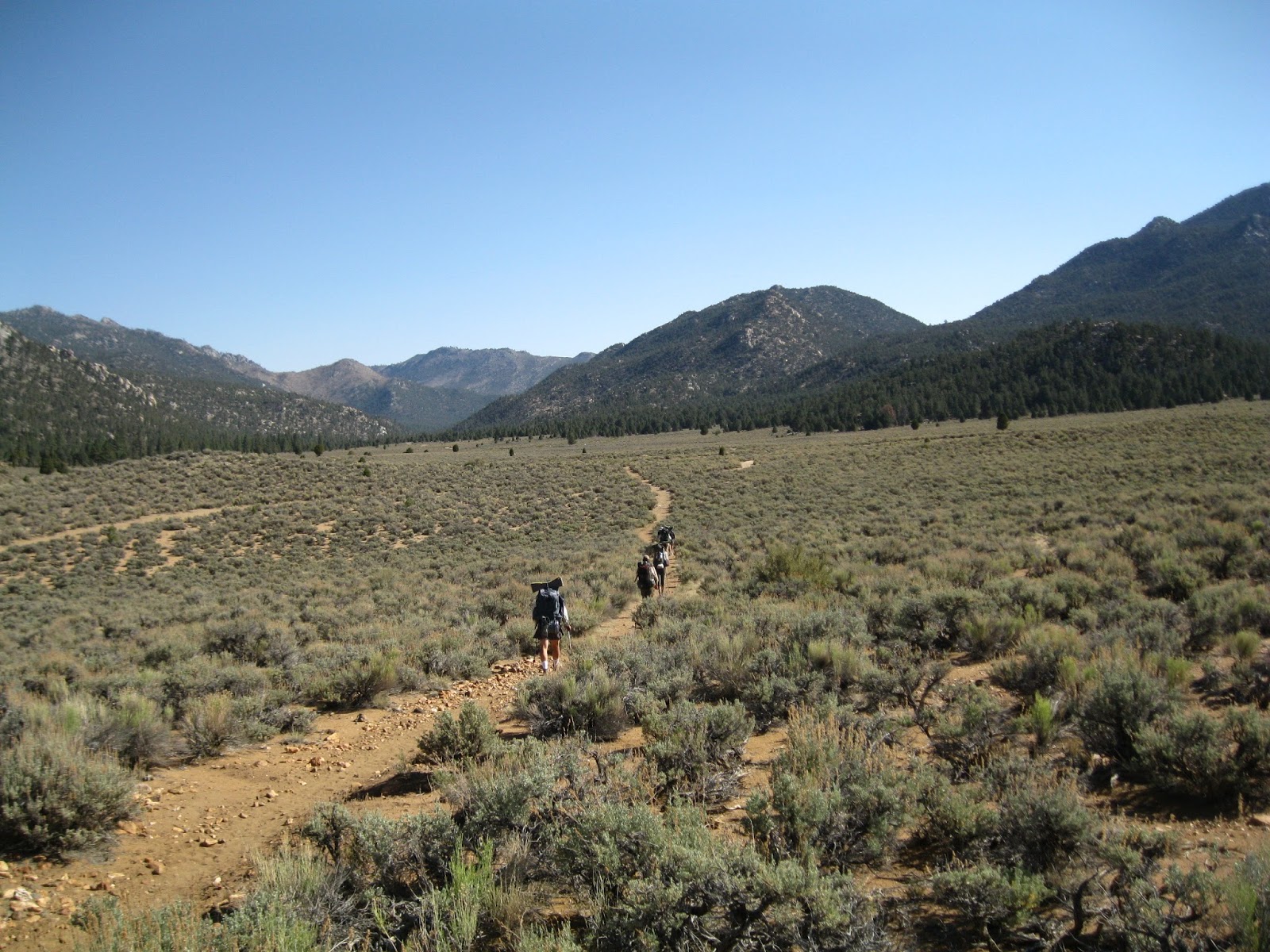
6/13 - Day 49 - Onion Valley to Kearsarge Pass to mile 795 - 12 miles
The day we leave a town to get back on a the trail is always a hard day... especially when our bed at the hotel is as comfortable as the one we had in Bishop.  But we had a ride from our friend Ducky so we reluctantly left Bishop to hike back up over Kearsarge Pass back to the trail... it was a 5 mile uphill hike with an elevation gain of over 2,000 feet.  Combine that with 7 days of food means that our packs were heavy and our legs were tired afterwards.  Making it to the top was a great feeling but then we still had to hike another 2.5 miles till we were actually back on the PCT.  Then once we did that we had to climb over another pass - Glenn Pass - which was only 2 miles more but extremely steep.  It was much harder than we expected.  I would say one of the hardest passes we did which was weird because it was so short.  The way down was pretty sketchy too with a bunch of snow and ice covering the trail.  But we made it and had a beautiful spot to camp at by a lake.  That night there were three deer hanging around and they didn't seem to mind us one bit.  They were running through our camp and just ignoring our presence.  It was really awesome and beautiful.  We thought that it was a once in a trail kind of an experience but throughout this whole week we have had very similar experiences... once I was having a conversation with another hiker and a deer just sat laid down about 10 feet away from us and didn't care much that we were there.

6/14 - Day 50 - mile 795 to 813 - 18 miles
We woke up bright and early... it was a cold morning so we packed up our stuff fast and headed off on the trail.  We had a beautiful 5 mile downward hike in which we got sort of lost for about 20 minutes and I ended up getting my feet soaked in a river that we didn't actually have to cross.  In spite of that, we still were having a really great time... and we were excited to get to mile 800! It felt like we had been in the 700's for so long!  Mile 800 marked the start of Pinchot Pass which in our opinion was one of the hardest this year.  2013 is a very strange year here on the trail... there is almost no snow - even on the passes - which makes our experience very different from other years.  We have talked to people who hiked in 2011 and they don't even remember going over Pinchot... but they remember a couple others to be very hard and difficult that we thought to be some of the easier ones.  But back to Pinchot.  It was a long, steep, 8 mile uphill climb.  I had expected us to finish it in 4 hours because even on uphills we normally were averaging 2 miles an hour... but not on Pinchot.  This one took us a very long time.  It was beautiful, don't get me wrong.  We followed an amazing stream up a valley for a very long time and had amazing and gorgeous views but boy were we pooped.  So pooped that a mile before the last push to the top we stopped and had to eat lunch to give ourselves a little extra energy.  But boy getting to the top of that pass was really satisfying.  I don't even remember going down Pinchot - the experience of the ascent eclipses it so much.  We made it down to the bottom and went a couple more miles back uphill towards the next pass (Mather Pass) so that we could hit it early in the morning.  That night we camped with a bunch of other people at a beautiful stream that luckily didn't have too many mosquitoes.  It was rather cold that night and we both woke up the next morning to find that the condensation in our tent had frozen and our sleeping bags were covered in a thin layer of ice.

6/15 - Day 51 - 813 to 835 - 22 Miles
Up Mather Pass!  We loved Mather Pass!  It was not too steep on the way up, short section of switchbacks, and great views on the way up, from the top, and on the way down.  This pass however is one of the passes that in previous years has been really hard for hikers due to the snow.  Not the case for us.  We loved it.  One of the best hands down.  We were up and over pretty fast and started the 10 mile descent.  What a gorgeous, gorgeous downhill descent.  It was rather steep at times but completely worth it. Again we followed a river down into a valley and there were just tons of waterfalls all day long.  They were coming down the side of the mountains around us just gushing into the stream we were following.  Oh it was great.  Although it was beautiful I was pretty happy when the descent ended.  My knees were pretty sore from the constant pounding they were taking from going downhill.  But I was also pretty intimidated of the pass up ahead.  We were about to start going up to Muir pass - an 11 mile uphill climb that I heard was pretty hard.  MudD however was very excited and insisted that we do another 7.5 miles up towards the pass to make the next day easier on us.  And I'm glad we did.  Again we had a beautiful campsite right next to a river with a waterfall a couple feet away from us and more friendly deer running through our campsite.  The first 5 miles were fine but the last 2 were really hard and really steep.  But I'm glad we did them... MudD was right, it did make the next day easier.

6/16 - Day 52 - 835 to 855 - 20 miles
Up Muir Pass! So the place we camped the night before set us up for having to hike under 4 miles to the top of Muir Pass.  Although it was tough and steep and we often lost the trail due to snow it was hands down our favorite pass.  We would hike up these switchbacks that would plateau out into a lake that we would walk around and then up more switchbacks to another lake that had a stream flowing into the lake we had just left.  Amazing, just amazing.  At the top of the pass there was a hut that was built in the 1930's I believe by the Sierra Club.  It was built for hikers stuck at the pass in bad weather and even though there was not a cloud in the sky when we were up there, but hut was still really cool and amazing.  It was made out of stones from the area and it blew my mind that people had actually hiked up there with enough supplies to build that hut.  Muir Pass is one of those things that we experienced that is too cool for words... I hope our pictures will give a little taste of our experience.  The rest of the day we spent doing a knee-breaking 23 mile descent.  It was great and beautiful and we even got to ford our first big river.  Like the passes though, it was much easier for us due to the fact that there was such little snowfall this year.  Our guidebook told us that sometimes that river could reach up to your chest!  The water at the place we crossed at didn't even reach our knees.  We found a waterfall off the side of the trail to have lunch at.  MudD was even brave enough to take a swim in the freezing cold water coming down it.  That downhill was so long that MudD and I couldn't even finish it that day.  We camped beside a river and had another great fire and slept great, excited for the next day and the next pass.

6/17 - Day 53 - mile 855 to 879 - 24 miles
We finished up the rest of the downhill from Muir pass and then started up Selden Pass.  Selden Pass was long but mostly gradual.  We sped up that thing faster than any other pass... partly because of the gradual grade but mostly because of the smoke in the air.  There was obviously something on fire that was not supposed to be... it smelled like a fire and the smoke scared me into flying up that hill.  MudD was less concerned but happy to be moving a pretty good clip.  We spent very little time at the actual pass because even up there the mosquitoes were biting us.  All day long we were getting eaten up... especially on our lunch break.  There was hundreds of mosquitoes swarming us for those 30 minutes.  It was awful but it was worth stopping for a good meal.

6/18 Day 54 - mile 879 to 901 - 22 miles!
We did our last pass in the high Sierra today - Silver Pass.  It was great!  I can't write much about this day because I'm running out of time on this library computer and we still have to upload pictures!  The highlight of the day was getting to mile 900 - what an amazing feeling!  The next day we ran into town!  We got a hitch, got a place to stay, and at a ton of food!  We are having a zero day and then heading out again tomorrow, the 21st to celebrate the summer solstice on the trail!!


 Headed back to the trail after Kearsarge Pass

 Made it to mile 800.2

 MudD at the top of Pinchot Pass.

On the way up Muir Pass.  It was so clear that day all the lakes reflected the mountains around them.

 The hut at the top of Muir Pass

 Heading down Muir Pass.

 Fire! Hanging out at camp.

 Holy cow mile 900!

Wednesday, June 12, 2013

Our first week in the Sierra

After our last week in Southern California, we were pretty beat up and looking forward to a change in scenery.  We had always heard that the Sierra Mountains are mostly everyone's favorite section of the PCT but nothing we had heard prepared us for the beauty that we encountered this last week.  These last 7 days have easily been our favorite on the trail with one beautiful and extraordinary view followed by another.

6/5 - Day 41 - Mile 702 to 716 - 14 miles
We took off from Kennedy Meadows a little later than we normally do but only planning on going 14 miles.  We were planning on dropping our daily mileage down to under 20 every day due to hiking at higher elevations and harder uphill climbs.  Honestly this first day wasn't too hard but we were enjoying the scenery too much to go much faster.  The day started out walking out of KM on flat ground and really soft sand but after a few miles we started climbing up into the high Sierra.  That first uphill climb was long but nice and gradual.  We took our lunch break right before the top of that first climb.  It was a nice place but nothing compared to what it looked like on the other side of that mountain.  When we started descending, we found ourselves looking out into a beautiful meadow.  I guess when I think of mountains, I think of steep slopes and deep valleys but what I didn't realize was that we would be encountering a whole bunch of these beautiful, flat meadows, with gorgeous flowers and flowing rivers.  It was so great there that even though we had just had our lunch break, we set our bags down and enjoyed another 30 minutes, hanging out with some other hikers and looking out into the meadow.  I would have loved to stay there but I knew there was only 3 more miles and one more climb till we came to another meadow - this one with a river - where we were planning on camping anyway.  So on we went to the next meadow which was just as beautiful as the first.

That night there was a thunder storm a couple miles away and we got hit with a nice light shower of rain.  It was a really nice "welcome to the Sierra" shower.  It was just a great day and we couldn't wait for more.

6/6 - Day 42 - Mile 716 to 735 - 19 miles
Today was a very big day for us... it was the first day we would get to over 10,000 feet in elevation.  I had looked at the elevation chart beforehand and had been dreading the climb a little but honestly it wasn't that bad.  Yes it was hard and I had to stop to catch my breath a time or two but the Sierra Mountains are just so beautiful that I find they distract me from the physical challenges of the day.  I can't say enough about how much I love hiking in the Sierra! This day again was filled with hiking up ridges that leveled out into amazing meadows.  We took our lunch break at one of the most amazing water sources we had seen so far.  It was just a little spring coming out of the ground a little bit off the trail.  The water was clear and cold and though it was hot in the sun that day, we found a nice place in the shade to rest our feet.  But all good things must come to an end so we packed up from our lunch break to start the next uphill climb - up to 10,500 feet.  When we got to the end of this climb, we found an amazing spot a little bit off the trail and though it was only 5 pm, we decided to call it quits for the day and set up camp.  That night the stars were amazing and bright and we slept really well.

6/7 - Day 43 - Mile 735 to 750 - 15 miles
We woke up this day to an amazing sunrise... the best one we had seen up to this point of the trip.  Our original plan this day was to try to go 25 miles which would set us up for a 7 mile hike the next day before we reached the base of Mt. Whitney so that we could summit Whitney on my birthday.  We were right on track to do it too but we took our lunch break at an amazing lake called Chicken Spring Lake and decided to just pack it up for the day and enjoy the lake.  We had a long and hard 9 mile uphill hike to the lake (11,000 feet) and even though I was happy to rest at the lake all afternoon, MudD was feeling antsy still so he went on a little adventure by himself.  The lake was backed by a mountain that went up and around to the other side... so MudD went up and hiked the whole thing.  Took him about 2 hours to do it all and even though the terrain got pretty sketchy towards the end, he really enjoyed himself.  The pictures he took were awesome and the views he had were amazing and beautiful.

That night we were joined by about 15 of our hiking friends who were all planning on doing the same thing we were - hike 20 miles the next day, camp 5 miles from the summit of Mt. Whitney at Guitar Lake, and summit the next morning by sunrise.  So we had a great time that night, sitting there and relaxing with all these people that had turned up to join us for the night.

6/8 - Day 44 - Mile 750 to 766 - Then off the trail to Guitar Lake - 20 Miles - My birthday!
Gosh, what a great birthday this was.  I can't think of another birthday that I have ever had that was even close to being like this one.  It was really fun and really beautiful.  The first 10 miles were fine.  It was up and down and then just downhill back to 9,000 feet.  We took a long snack break with a whole bunch of friends at a river because we knew we had a long and steep uphill hike ahead of us.  We ate some food to sustain our energy levels for the 3 mile long stretch that would take us up 2,000 feet in elevation.  Even MudD admits that it was a rough climb... perhaps the hardest of the trip so far.  I was feeling strong until the last push when we started approaching 11,000 feet.  This last push I had a really hard time catching my breath and boy was I feeling the elevation.  But we made it to the end which was really exciting... until I realized I had left all our maps for the day and our journal at the bottom of the mountain at our snack break sight.  Even though both of those things are very precious to us, it wasn't worth doing that climb again so we pressed on.  In no time we had made it to the trail that we would take to summit Mt. Whitney.  Whitney is not actually a part of the PCT... the PCT actually just runs by the base of the mountain.  But it all in all the trip would only add 17 miles to the trip and who knows if we will ever get another chance to summit the highest mountain in the lower 48 again? Even if we did get another opportunity, we would never be in as good of shape.  So we went for it.  Our plan was to go a little less than 4 miles up the trail to Guitar Lake... one of the last places to camp by a water source before the summit.  Again, the stars were absolutely amazing that night - we could clearly see the Milky Way - and it was just a beautiful night.  It is definitely the best camping spot we had the entire trip so far and we have a feeling it will probably be in the top 5 by the time this trip is over.

6/9 - Day 45 - Guitar Lake to summit of Whitney to mile 774 - 21 miles
WOW WHAT A GREAT DAY.  We woke up at 2 in the morning by Guitar Lake and started the 5 mile ascent to the top of Whitney.  We wanted to get to the top in time to watch the sunrise.  We left most of our stuff at Guitar Lake and just carried our packs, sleeping bags, warm clothes, some snacks, and 2 liters of water up to the top of the mountain (it was amazing to feel so light and liberated!).  I'm not going to lie, even though we left most of our stuff at our base camp, that hike was hard.  I think perhaps it was better that we did it in the pitch dark with just our head lamps to guide our way because if I had been able to look up and see how much farther we had to go, it may have been much harder mentally.  But we had no idea where we were or how much farther we had, just that we had to walk to stay warm.  The first hour wasn't too bad but the higher we went in elevation, the colder it got.  We started to see some color in the sky around 4:30 and even though we knew we had an hour to go before the sun would come above the horizon, we were worried we wouldn't make it.  If I thought hiking at 11,000 feet was hard, it was nothing compared to going up to 14,000 feet.  We were going pretty slow but honestly I don't think I could have gone much faster.  We got to the last push a little bit before 5 am and we both got a sudden burst of energy when we could see the small shack that sits on top of Mt. Whitney.  It was freezing up there! We both immediately took off our wet, sweaty hiking clothes and put on our warm, dry pajamas, crawled into our sleeping bags and sat on the edge of Whitney and waited for the sun to rise.  It was pretty awesome.  We did that morning hike with: Hermes, Lotus, Mystique, Werewolf, Sierra Bum, Horny Toad, Mermaid, Walkie Talkie, and Happy Feet.  We met our friends Unicroc, Scattracker, and Lullabye at the top... they had reached the summit the night before with all of there stuff and had camped there for the night.

We stayed up there for a little while longer but it was much too cold so we went back down.  I am very happy we decided to do it at sunrise not just because it was very beautiful but also because as we went down, a ton of hikers (day hikers and through hikers) were coming up for the day.  We got up before the crowds and started the day off right!

When we reached Guitar Lake again, we packed up our stuff and headed off.  We were anxious to get back on the trail.  It was only 9 in the morning but we had already hiked 10 miles.  When we reached mile 767 we were not only back on the PCT but we had also met up with the John Muir Trail - a trail we will be following through the Sierra.  Even though we were absolutely exhausted from our early morning hike, we pushed on.  The next day we would be going over Forester Pass - the highest point on the PCT - and wanted to get closer so that we could do it early in the morning.  Those next couple of miles were rough on us.  We were pretty tired and stopped a lot for breaks and even though it was half a mile from where we were planning on camping, we found great camping at 4 pm and stopped for the day.  We set up shop, cooked some food, played some cards with Unicroc and Scattracker (they killed us in euchre), and headed off to bed.

6/10 - Day 46 - Mile 774 to 788 - 14 miles
This is easily my favorite day of the hike so far.  We woke up early that morning and knew that we would be climbing to 13,000 feet that day.  I guess I was imagining it would be a lot like Whitney and just hard... but it was the most beautiful and fun day yet.  Everything I had read about this pass scared me... I had read horror stories of people hiking through snow for 5 miles, not knowing where the trail was or which dip in the mountain the pass was and then getting to the top only to have a sketchy and scary hike down through deep, waist high snow.  But I guess our year is really unusual... there was virtually no snow.  So we had the trail the whole way and my oh my what amazing scenery.  We would walk up to a lake, stop to take pictures and admire it only to move on and walk past an equally breathtaking lake that was actually flowing into the first one. And the hike was just plain fun! Such a good time.  I really don't know what to say about it because it was just too amazing to describe.  Best day ever.  And one of the best parts was that when we got to the top, the beauty didn't stop! We followed a few amazing creeks and streams as we descended into a valley.  We took an amazing lunch break at a small water fall and went swimming with our friend, Mermaid, who we had been hiking with for the past couple of days.  Everything was going just right until MudD looked up in the sky and said, "guys we have some pretty scary looking clouds coming our way."  And boy was he right.  We packed up our stuff and headed on down the trail.  We got another 4 miles before we started getting rained on.  We had wanted to hike the rest of the 8 miles till town that day but we knew we had to go over another pass that day to get to the town... and though it wasn't at 13,000 like Forester, it was still pretty up there.  We decided to set up the tent and wait out the storm.  I'm happy we did because even though the rain  lasted about 2 hours, we were able to find some dry wood and had a great fire that night.

6/11 - Day 47 - Mile 788 to 788.5 to Onion Valley Trailhead via Kearsarge Pass - 8 miles
So we had planned on going into the town we are in now (Bishop, CA) but to get there, we had to walk about 7.5 miles down a different trail which lead over Kearsarge pass.  So that's what we did.  We were all pretty low energy that day but it was gorgeous and beautiful like the rest of the week and at least we were dry.  We made it to the top of the pass and ran into our old friend, Ducky, who happened be getting day hiking that day and offered to drive us the 50 miles into town... and then drive us back to the trail when we were ready.  So now we are in town and its great and we can't wait to get back on the trail!  But we are spending a zero here because it's a cool little town and because MudD's mom is awesome and booked us a hotel here in town as birthday presents to us. THANKS DEBRA BELL!!!!!!!! So we are relaxing and taking care of ourselves before heading out into the beautiful Sierra Mountains again!

 Heading out of Kennedy Meadows towards the mountains!

 Our amazing campsite at mile 735. This is where we spent the night of our 2 year anniversary!

 MudD on his little adventure over Chicken Spring Lake.  That is the lake there below.  MudD: "I crowned it!"

 Guitar Lake - the picture doesn't do justice to the actual place. Most beautiful spot we have camped at so far.

 Waiting for the sun to rise on Mt. Whitney. Brrrr!

 The sunrise!

 On top of Whitney

 Descending Whitney... going through one of the two patches of snow left on the trail.

 Me. The Dingo.  That's Guitar Lake there to the right. MudD made me climb out on a ledge for this photo.  That is why it looks like I'm scared... I am.

 On the way up to Forester Pass

 MudD pointing out the pass to me.  The pass is the little dip to the left of the dip his finger is pointing at.

The trail heading up to the pass

 MudD looking back at what we just hiked up

 MudD and our friend Stats sitting in the pass looking over to the other side.

 Our swimming pool with the waterfall!

Stats, MudD, Dingo, and Mermaid at the top of Forester Pass!

The view on the way up to Kearsarge Pass looking down at Kearsarge Lakes

Pictures from the last week in Southern California

The internet at Kennedy Meadows was pretty slow so we couldn't upload all the pictures we wanted to.  Here are the picture highlights from the last week in Southern California.
Our campsite on a really windy day.  These plants saved us from the wind and let us get some sleep!
Walking through a burn zone
MudD
 We couldn't get a good picture of the 600 sign so we made our own.  We were much happier than it seems from the picture
 Water cache at mile 615! So amazing!
 Cruising through the desert... trying to get out as fast as possible
 Little baby bear cub that was hanging out around a water source.  Kind of freaky but no Momma bear in sight
 Mile 700!!!!!!!!!!!!!!! YEAH!
Everyone hanging out at the General Store in Kennedy Meadows!

Monday, June 3, 2013

Done with Southern California!

Okay so from the last post to now we had to walk 144 miles in 7 days to get through the last of Southern California.  We figured that would be no problem.  We figured we had to do just over 20 miles a day and the thought of the Sierra Mountains would keep our spirits high and help us push through the last of the desert.  Boy were we wrong.  This has been the hardest week - not only physically but also mentally - of the whole trip so far.

5/28 - Day 33 - 20 miles - Mile 558 to 578
The day before we had decided to take another zero day in Mojave due to bad weather.  We had heard that there were gusts of wind up to 78 mph in the high desert... We figured the storm would blow over and this day it would be safe to leave.  But it wasn't.  We took off around 9 in the morning in the middle of a rain storm and had to walk through another wind farm. It was absolutely miserable.  We were cold and wet so when we saw another person had set up their tent behind a large bush that blocked most of the wind, we decided to follow suit and wait out the storm.  We had walked only 4 miles by this point.  We were just considering giving in and going back to town to try again tomorrow when the rain stopped and the sun came out a bit.  The wind was still blowing like mad but at least it wasn't raining.  So off we went and again, we thought that maybe we had seen the worst of the weather that day.  But then we had to go up a mountain and found ourselves literally walking into the storm.  We were just on top of the mountain being blown every which way by the wind.  I had no idea how we were going to sleep that night in the wind but we found a great spot with a couple of other hikers where the bushes were large enough to block most of the wind.  We even slept really well that night.  And I guess we were lucky that the weather we saw that day wasn't worse... later on this week we have been able to talk to some of our hiker friends who took off the day before and it sounded like they just had the worst time ever. One of our friends said she was actually stuck on top of the mountain because the wind was so strong that she couldn't move forward.  She ended up sitting there for half an hour or so and then crawling her way across till she found some refuge.  So all in all I guess our day was pretty miserable but hey, at least we weren't out there the day before.

5/29 - Day 34 - 24 miles - 578 to 602
Gosh, what a great day this was. Probably the best one of the week.  It started off going through some more wind farms and through a really burnt area of trail but ended in a really beautiful area with trees and the ground was a little wet and we had enough water that night... oh it was amazing.  MudD even saw a bear!  He said that as he rounded a corner in the trail, he saw it maybe 20 yards ahead of him.  They made eye contact and then the bear took off running down the trail!  It was a pretty hard day but we made good time and even had enough time to take a really nice lunch break in the middle of a really hard but beautiful climb.  Our spirits were soaring at the end of the day - we were certain that the trees and the bear were a sign that the desert was officially over and the road to Kennedy Meadows (the official end of Southern California) was going to be fun and easy. But our hopes and dreams were crushed that night when we looked at the water report for the next day.  We were at mile 602.  There was water at 609... and then no water on the trail until mile 664.  What?  How is that possible?  There were a couple of water sources about a half a mile off the trail and a couple of other water caches that trail angels might have left on the trail but other than that, nothing.

5/30 - Day 35 - 29 miles - 602 to 631
So we went hard this day.  We heard that water cache at mile 631 was pretty reliable and we could get water at 621 if we went about 1.5 miles out of our way.  Somehow we also walked out of the beautiful trees and smack dab into the desert again.  The real desert too with small little shrubs and no place to sit in the shade to cool down.  Luckily the water cache at mile 615 was completely full so we both drank a liter of water there and kept heading on.  It was only 10:30 and wasn't too hot out.  I think as soon as we were about a mile away from that water cache it got extremely hot. Boy were we sweating hard.  This was not fun.  And the worst part about it was we had to keep going and get to the next water source.  It was too hot to not drink a ton of water and so by the time we had 5 miles to go, we both only had about a liter and a half left... so we had to do it.  We were dead tired, probably pretty dehydrated, and to be completely honest, not having any fun at all.  Those last 5 miles really took it out of us.  They were hard, hot, and uphill.  Plus the ground was really sandy and the wind had picked up so it felt like every step forward was just an absolute struggle. We made it to the water cache and luckily it had plenty of water.  We tried to find a place to camp out of the wind but it was back and blowing hard again.  Both of us felt slightly sick and had to force down water and food which we knew our bodies needed but we had no desire to consume anything.  After sitting for a while and relaxing in the shade we started feeling better.  That night we tried (but failed) to get a good night's sleep because we knew we had 33 miles to go without any water the next day and it was probably going to be hot again.

5/31  - Day 36 - 20 miles - Mile 631 to 651 - MUDD'S BIRTHDAY!!!
MudD's birthday would have been pretty miserable if not for the amazing trail magic we experienced at Walker Pass at mile 651.  The day was actually okay at first. We had a nice climb that took us into some trees but then we quickly headed back out into the miserably hot desert.  We were both carrying insane amounts of water so that we could make it through that day, camp, and then hike the next day till water and not be completely dehydrated.  The only problem with being water conscience (for me at least) is that every sip of water I take makes me feel anxious... I think hmm maybe I should have saved that for later.  And then the entire time I'm walking I'm thinking about how much water I am carrying, how much water I should have going into camp that night, and how much water I can drink that night to still have enough the next morning to make it to the water source.  It's very stressful and not very fun.  So walking down into Walker Pass I was really worried and nervous because I was drinking the water I had planned on having that night at camp to drink.  Plus I was worried because MudD was having no fun on his birthday and I felt bad.  And then we walked into Walker Pass and we saw a sign that said, "Trail Magic - hikers come down to the blue tent" and the day immediately went from terrible to amazing!  There were trail angels there that we had always heard of - Yogi and Meadow Ed - and I felt like I was meeting celebrities.  They greeted us with ice cream sandwiches and strawberry cakes and made us amazing spaghetti that night.  Plus they had beer, sodas, and all the water that we could drink.  Really it was the best thing that could have happened on MudD's birthday.  What a great surprise.  That night, had they not been there, we would have been fine.  We had enough water to get by, we had enough food we could have prepared that did not need water, and there was plenty of shade in the area. We would have been fine physically.  But boy of boy mentally we were down and this was just the best upper in the world.  People were having fun, laughing, and not worrying about water and that - not worrying about water - is one of the best feelings in the world I have found.  Plus MudD had a good birthday.  So it was great.

6/1 - Day 37 - 22 miles - 651 to 673
This day was again hotter and harder with less water than we expected.  Again we thought we were out of the clear and that water would be abundant after the next 13 miles.  But the water sources were getting pretty low and looking like they were drying up.  Luckily we got to them but we are pretty worried about the people a week behind us.  I hope the water doesn't dry up on them.

Other than it being hot out, the day was pretty nice.  We had three significant climbs to do but we a great dinner the night before and the trail angels had made us pancakes that morning so we were fed and ready to go.  The first two went by pretty quickly and smoothly and the third was fun even though it was pretty hard.  Some of our crazy friends decided to do the next 52 miles to Kennedy Meadows in one day... and they made it! It took them 18 hours and 14 ibuprofen but they made it there.  MudD and I decided to not do the 52 miles in 24 hour challenge and take our time with it. I'm glad we did because that campsite we had that night was beautiful.  We were right on the top of a ridge in a saddle of a mountain but had great views and watched the bats eat bugs all night.

6/2 - Day 38 - 25 miles - 673 to 698
This day was easily the worst day on the trail.  It wasn't hard, I wasn't dead tired at the end of the day, but mentally we were both over this day.  We walked through a burn zone for most of the day and just hated every step.  The only motivation we had was that we knew there was a river at mile 698... an actual river!  Gosh I don't even know what to write about this day besides that it was just horrible.

That night we camped at the river after taking a long dip and took out the map.  We realized that we had exactly 1,000 miles to go before we were out of California.  We may be over 1/4 of the way through the trail but not even half way through California.

6/3 Day 39 - 4 miles - 698 to 702
KENNEDY MEADOWS THANK GOD!!!!!!!!!!!
So Kennedy Meadows is one of the big iconic places on the PCT.  Making here means that we are out of Southern California... a place both MudD and I have grown to dislike a lot.  And apparently we're not the only ones.  When we got here we compared stories with other hikers and they all had the same experience we did... they hated it!  One of our hiker friends even said, "if the desert was one week longer I might have quit."  Everyone is very excited for the Sierra Mountains!!

Kennedy Meadows itself is a really cool place.  There is a general store where all our packages have gone to (THANK YOU EVERYONE WHO SENT US A PACKAGE WE LOVE AND APPRECIATE IT!!!) and everyone is hanging out here for a couple of days, trying to put some weight on before heading off again on the trip.  MudD and I are going to take a day or two here to recuperate and get excited about heading off into the mountains!  We are very excited to be heading back into bear country!  Away from the desert!  Towards water! Towards snow! Towards cold temperatures! We are so excited!!!!!!!!!!!!!!!!!!!!

The internet is really slow so we were only able to load one picture so far.
Also, if you want to send us a letter or a package we will be at:
Franny Newport/MudD Hemberg
C/O Chevron
PO Box 403
Independence CA 93526

We will be there between June 10 and June 12!!!!
One of the many wind farms we walked through